A walk up and around the hilly terrain around Marysville township.
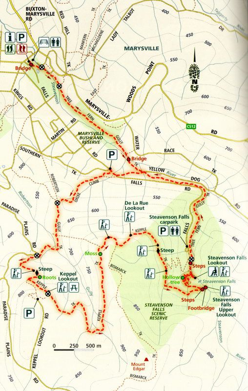
At 14.9km long this walk on the map didn’t look too hard to do. But it’s very hilly, and climbing to the top of Steavenson Falls takes an effort but it’s worth it for the magnificent views. There are signs warning of the difficult climb and I was surprised to see a father clutching a toddler on a narrow track where one false move would send them both down the steep slope.
Once past Steavenson Falls most of the scenery is of the distant hills. De La Rue lookout has some nice views but it seemed further along the track than it should have been.

Keppel Lookout
Keppel Lookout has a nice viewing platform and you can drive to it. If you’re a walker you kind of despise those who took the easy way to get the beautiful view; it’s like they didn’t earn the chance to see it.
The walk from Keppel Lookout to Gallipoli Park seemed to take ages. We thought our progress was good until reading the map we were a good distance from the relatively easy path in Gallipoli Park. We were very glad to see the Visitor Centre!


Conclusion
A fine walk that is best done when the weather is good. Steavenson Falls can get very busy so try and go off peak like during the week if possible. Away from Steavenson Falls the tracks are very quiet. The nearly 15 km of track is hard going in places and it’s a good idea to take plenty of water and some snacks to eat on the way. Proper bush walking shoes are a must as it can get slippery on the steep sections of track.
Photos


Reference
Top Walks in Victoria by Ball, Melanie. Book – 2014
